How did a 14th-century mapmaker draw a world he couldn't see for himself?
To fill in the world beyond the sea charts, one mapmaker stitched together sailors' charts, Marco Polo's travel tales and the Antichrist, all on the same set of vellum leaves.
▶ Start the storyBy combining two kinds of borrowed knowledge: sailors' charts for the coasts, and travellers' books for everything beyond. Around 1375, Cresques Abraham, a Jewish cartographer who led the Majorcan cartographic school, produced what is now called the Catalan Atlas, described as the most important medieval map in the Catalan language. Its western part closely follows the portolan charts sailors already used; its eastern part blends older mappae mundi with travel literature, above all Marco Polo's Book of Marvels and Mandeville's Travels. It was in the French royal library by 1380 and survives today in the Bibliothèque nationale de France.
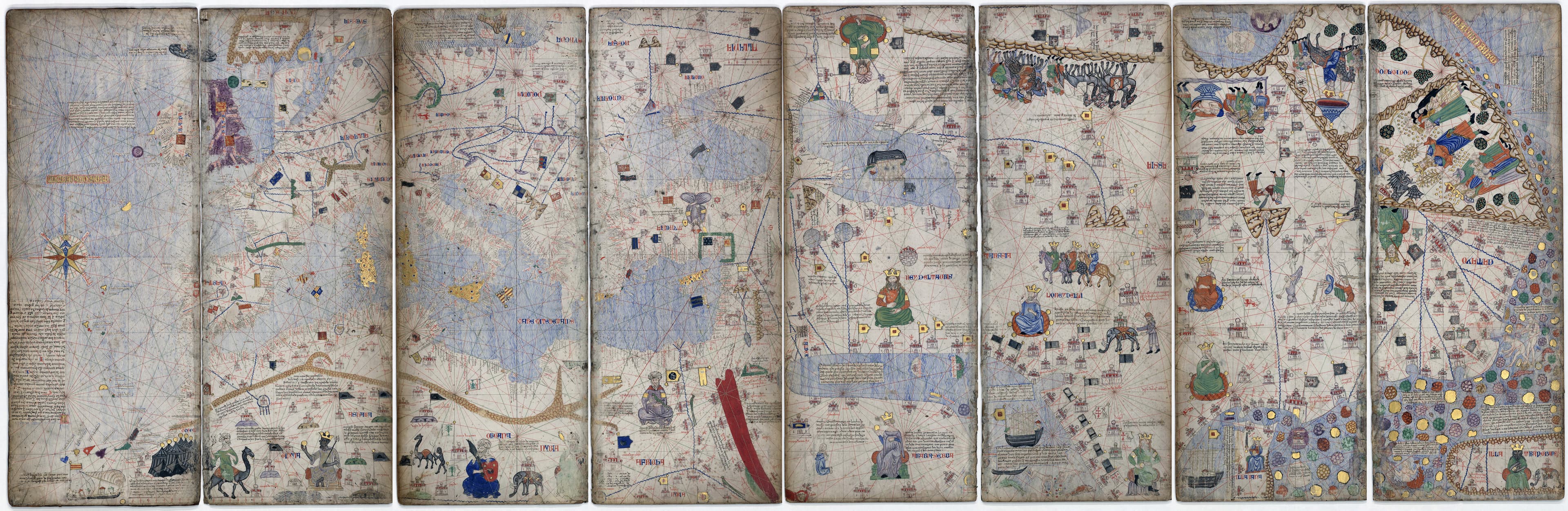
The atlas opens with two leaves of text on cosmography and astronomy, stressing that the Earth is round and giving sailors practical help with tides and telling time at night. The map proper, spread over four more leaves, puts Jerusalem near the centre, with Europe and Africa on one side and the Orient on the other. On the western coasts Cresques even added the first compass rose known on such a chart. Farther east and south, he had to rely on other people's stories for cities, rulers and riches he could not check himself.
The result mixes real information with guesswork and legend. The Mali Empire appears under Mansa Musa, captioned as the richest and noblest lord of those lands; the historian Hadrien Collet sees this caption, often misquoted today as 'richest man ever', as an early stage of the myth of Musa's wealth. In the Sahara, a kingdom called 'Organa' carries a European-style flag, although no medieval African kingdom bore that name, a sign of how poorly Europeans knew the interior. In India, the Sultan of Delhi commands seven hundred elephants and a hundred thousand horsemen, while a 'King of Colombo' flies a Christian flag, information probably drawn from the missionary Jordan Catala's 1340 Book of Marvels.
Farther still, fact gives way openly to myth. In the top right corner lies the land of Gog and Magog, with Alexander the Great pointing to a fortress where he means to confine them, and just past the Great Wall of China the mapmaker placed the Antichrist himself, with a caption foretelling that he would begin preaching in Jerusalem at the age of thirty.
Quiz me
0/3
Recap
When a medieval mapmaker ran out of firsthand knowledge, he filled the gaps with travellers' books and religious legend, right alongside the parts he could verify.
Surprising fact · The map depicts the Antichrist beyond the Great Wall of China on the same sheet of parchment where it accurately shows real rulers like Mansa Musa and the Golden Horde's Jani Beg.
Sources (1)
No source, no claim. Every fact in this lesson (17 claims) cites at least one of these.